Coauthor Adán Castro Añorve
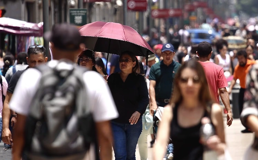
Major cities worldwide are experiencing an increase in temperatures due to climate change, lack of green spaces, and the heat island effect. In 2023 alone, Mexico City faced four heat waves and heat strokes, which raised body temperature to around 40 degrees and could be fatal.
To counter these heat waves, many cities globally are investing in creating more green spaces—areas with natural or induced vegetation in the form of parks, squares, or wooded zones. Green areas can mitigate high temperatures, directly influencing the improvement of the environment’s quality in large urban areas.
In Latin America, 17 cities have undertaken improvement projects to maintain and expand their green areas, with the Brazilian city of Curitiba leading the way. Other notable cities for their improvements include Belo Horizonte, Bogotá, Brasília, Rio de Janeiro, São Paulo, Medellín, Monterrey, Puebla, Porto Alegre, Quito, Santiago, while cities like Buenos Aires, Montevideo, Guadalajara, and Lima fall below the average.
In other parts of the world, green spaces, besides mitigating heat waves, also enhance citizens’ living conditions by providing spaces for sports, improving social relations, and strengthening ecological awareness. For example, New York has Central Park, one of the most visited urban parks globally, spanning 341 hectares; Barcelona has the Ciudadela Park, and Madrid has the famous Retiro Park, considered a cultural heritage.
In Mexico City, there are nearly 68 square kilometers of green areas, covering 4.5% of its surface in total. However, this is not sufficient for the more than 9 million inhabitants. The Green Infrastructure Program promoted by the city’s government aims to connect and increase the link between green areas and bodies of water, equally distribute the benefits of services to the population, ensure social confluence in these spaces, and incorporate actions to minimize the impacts of climate change.
Nevertheless, these efforts have not succeeded in highlighting the issue of the impacts of extreme heat on the health of marginalized areas. Environmental and health policies in Mexico City seem to be disconnected, and while there are strategies for adapting to climate change, plans, and programs do not seem to focus on the impacts on the environment and health concerning the increase in heat waves.
Within the same city, there are thermal and population vulnerability contrasts. Between the center and east of the city, there can be differences of up to 3ºC during periods of extreme temperatures. The city’s central and western areas are home to boroughs with a higher purchasing power, less vulnerable populations and more extensive green areas. In contrast, the east of the city houses populations with lower purchasing power, a high percentage of children and adults over 65, and few green areas. In this context, the proximity of vulnerable populations to green areas would alleviate the effects of heat waves.
While Mexico City averages 7.5 m2 of green areas per inhabitant, the World Health Organization recommends an average of 16.4 m2, more than double. Therefore, there is still a long way to go to achieve thermal comfort in the sixth most populous city in the world.
Community Maps
In this context, a useful tool for evaluating the efficiency of green areas is participatory cartography or community mapping. Creating these maps helps complement technical knowledge with the real-life experiences of people. It is an open process that captures ideas about how the territory, its environment, culture, problems, and possible solutions are understood, indicating the needs of the inhabitants.
A group of researchers from the National Autonomous University of Mexico is creating participatory maps to assess green areas as buffers against heat waves in Mexico City. They are also advancing the analysis of satellite images to map the temperature of areas with and without green areas in the east of the city.
The objective of the project “Citizen Consultation and Cartography on Green Areas and their Role in Public Health, Case: Extreme Heat in Mexico City” is to build communication bridges between departments and the community to improve public health. In this way, it is possible to promote the conservation of green areas and improve decision-making by public authorities, considering the population’s opinion based on participatory maps.
Thus, with the active participation of academia, the local government involved in green areas programs, and citizens with community mapping, it is possible to identify vulnerability hotspots and better plan green areas and healthcare services. All this will make it possible to face heat waves more effectively, which are becoming more frequent in Mexico City.
This text is a product of the Climate, Environment, and Health + Migration Program developed by the Inter-American Institute for Global Change Research IAI and Latinoamérica21.
Adán Castro Añorve is a Professor of Public Health at the School of Medicine (UNAM-Mexico). He is a doctor specialized in statistical methods, master studies in Complexity Sciences, epidemiological modeling and intelligence, health data analysis, and health emergencies.
*Translated by Ricardo Aceves from the original in Spanish


